
The Process of Phase 1 Land Contamination Assessments
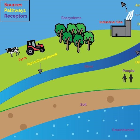
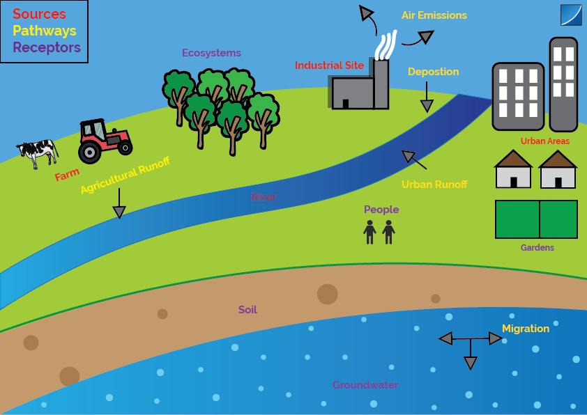
Phase 1 Land Contamination Assessment (LCA) reports are used as a tool to investigate the risk of contamination to a proposed development. The aim of an LCA report is to propose appropriate mitigation for identified pollution risks posed to a specific site area. This is in order to prevent pollution harming the surrounding environment or human health. (View the info-graphic above for the basics for a Land contamination assessment and what is included).
Existing baseline conditions of a proposed site are assessed to indicate potential sensitivity to pollution, or potential current or historical contaminative land uses within a radius of a site. A site walkover is carried out to confirm conclusions taken from online sources and reports. Which can also find further information such as specific risks of pollution from within buildings. E.g. poor management regarding the storage of fuels or harmful chemicals.
Historical and present-day contaminative uses and ground workings are assessed within a 250 m to 500 m radius of a site location. Identifying and analysing potential sources of land contamination is the first stage in producing a Source – Pathway – Receptor (SPR) model. Where potential sources of pollution are ascertained. Contamination originating from the existing site may remain within hydrological features, within the ground or within buildings or tanks. Common pollutants, from existing sites or contaminative uses close to a site location include asbestos, hydrocarbons, metals, and air emissions.
What else is included in a Phase 1 Land Contamination Assessment?
In order to understand the viable pathways that a pollutant can take through the environment. The baseline environmental conditions of the site and surrounding area are assessed. Geological and hydrogeological conditions are extracted from proprietary third party databases and British Geological Society (BGS) mapping. The characterisation of superficial and bedrock geology underlying a site is then used to assess the risk of ground water pollution. And the migration of pollution through aquifers. Considerations are taken from the processes of the proposed future development which can disturb or release pollution into the ground. Or produce pathways for contamination to migrate through strata. Soilscape online mapping gives an indication of soil composition for the site. Which is further used to gauge permeability of top-soils and the risk of pollution infiltrating into the ground.
When looking to complete an SPR linkage, there must be a receptor that is at risk of encountering a pollutant. Examples of receptors to pollutants include people, buildings, ecology, soils, surface water and groundwater. Hydrological features within 500 m of the site are identified within the database to establish the sensitivity of the local area to waterbody contamination.
Risk Factors
If an SPR linkage is identified to be feasible, the overall risk factors of the linkage are determined by the likelihood of the scenario and the consequence of pollution affecting a receptor (Table 1). Thus, a complete SPR linkage does not mean that a site is definitely at risk of contamination or the consequential effects. Mitigation methods such as top-soil replacement, asbestos investigation and intrusive land investigation can all be reasonably proposed from using the SPR model. If there is no SPR linkage in place, it is concluded that there is no risk of harm.
 Table 1: Risk Factors
Here at RMA we provide Phase 1 Land Contamination assessments. If you require any assistance on a project or require a quote please contact us.
Email: enquiries@rma-environmental.co.uk
Telephone: 01884 842740


